Culver Aviation shares its experience.
Once drones were invented, aerial photography ceased to be an expensive solution for the chosen ones. Today, anyone can now order this service from Culver Aviation. Our UAVs make quick overflights of large areas, followed by the transformation of the data into orthophoto plans of high accuracy and quality by our team.
The very first aerial photography was taken in 1858, and almost immediately this data-collection method became monopolized by the military: aerial photography was used to create maps and intelligence.
But the military's monopoly on taking pictures from balloons and airplanes didn’t last too long. Already in the 1930s, the technology became used in agriculture and geology. Aerial photography became widely used, especially due to the fact that its possibilities are constantly scaling.
Who aerial photography by Culver Aviation is for
Large agro holdings and farmers
For the agriculture industry, the company provides measurements — it determines the exact borders of the fields to calculate the area, as well as the surface of areas with large elevation extremes.
We also provide crop seedlings condition monitoring using NDVI — the normalized difference vegetation index. To do this, the drone uses a multispectral camera. Depending on the set parameters of the camera, the image will show areas that are sown poorly, the level of plant development, and foci of fungal diseases. Monitoring will help to make the right management decisions on time.
Construction companies, geologists, archaeologists
For these customers, life is made easier by orthophoto maps — terrain plans created by drone photos stitched together. They allow you to determine the condition and clear boundaries of the construction/exploration/extraction site and calculate the scope of work. For example, aerial photography can be used to determine the volume of materials on a construction site with an accuracy of 10%.
Mapping companies
Terrain surveying is a decisive way to gather information about terrain and objects. With the use of its UAVs, Culver Aviation surveys large areas in no time.
Public utilities
Aerial photography provides assistance with road certification. This method of surveying the area allows you to determine the condition of the pavement and the territory adjacent to the highways. A similar survey of the area is used to determine the condition of pipelines and other lengthy objects.
Forestry
Remote sensing allows you to effectively monitor the forest cover. It helps forest management to estimate the plot area, and identify the epicenter of the fire or the place of illegal logging.
Territorial communities and cadastral services
For these customers, just like for the agro sector, aerial photography makes it possible to clearly determine the plot area and assess its condition. This is necessary when planning construction or arranging the territory.
How aerial photography by Culver Aviation is performed
To monitor large areas, Culver Aviation uses self-developed SKIF UAVs, designed according to the "flying wing" scheme, while to research high-altitude objects it uses own-designed copters.
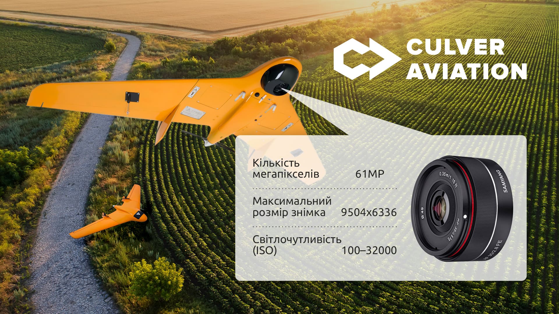
All the company's drones are equipped with high-precision 60 MP cameras with matrices capable of creating images with a spatial resolution of 1 cm per pixel. The images are so clear that you can count mushrooms in a basket or see cracks in the plaster of a building.
For most aerial surveys, this resolution is more than enough. For example, a resolution of 3 cm per pixel is sufficient for monitoring crop conditions, and 10-15 cm per pixel - for creating maps. Therefore, we adjust the technical parameters of the task, such as the image resolution, accuracy, and compliance with state standards, depending on the purpose of the research.
After overflying the territory and analyzing the information gathered, the customer receives an analytics report in an easy-to-use format.
Culver Aviation Benefits
- One of the largest UAV fleets in Ukraine, which allows us to quickly perform even large-scale research. For example, one plane can overfly 6,000 hectares per shift, and a large fleet of such devices can monitor areas of several hundred thousand hectares. Such a task is beyond the capabilities of companies with a small fleet or operators who use only copters. The fleet also guarantees the work to be performed on time: in case the equipment has to be maintained, it is replaced with another one.
- Information processing speed. This indicator ranges from several hours to several days, depending on the technical task, the accuracy, and image quality. By using aircraft in the field, Culver Aviation reduces aerial photography time.
- Upon-request order option. In contrast to the orbital monitoring of the Earth with the help of satellites, the UAV allows you to get the necessary information faster. Once there is an urgent need for surveillance, you don’t have to wait for the satellite to fly over the site.
- Information accuracy. Culver Aviation provides 100 times more accurate images compared to satellites.
Original article on